
After a marathon City Council meeting on December 16, San Diego approved three major items that will reshape housing, transportation, and planning for the Clairemont and College Area communities for decades to come.
The votes approved new Community Plan Updates for each area and established a new Community Enhancement Overlay Zone (CEOZ) that changes how local design and zoning standards are enforced citywide.
The Clairemont Community Plan Update
Public Comments: 19 in favor, 11 opposed
Outcome: Approved 7-1 by the City Council; City Council President Joe Cava was the single dissenting vote, stating his reason for voting no was that he didn’t think the plan went far enough.
District 2 City Councilmember Jennifer Campbell commented, “The Clairemont Plan Update has been in the works for 30 years, and I am grateful to the planning department and the mayor’s team for their work on this plan update, especially their commitment to working with the community to incorporate residents’ feedback.”
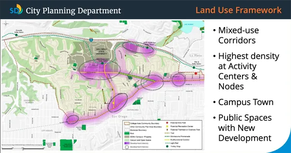
What It Does
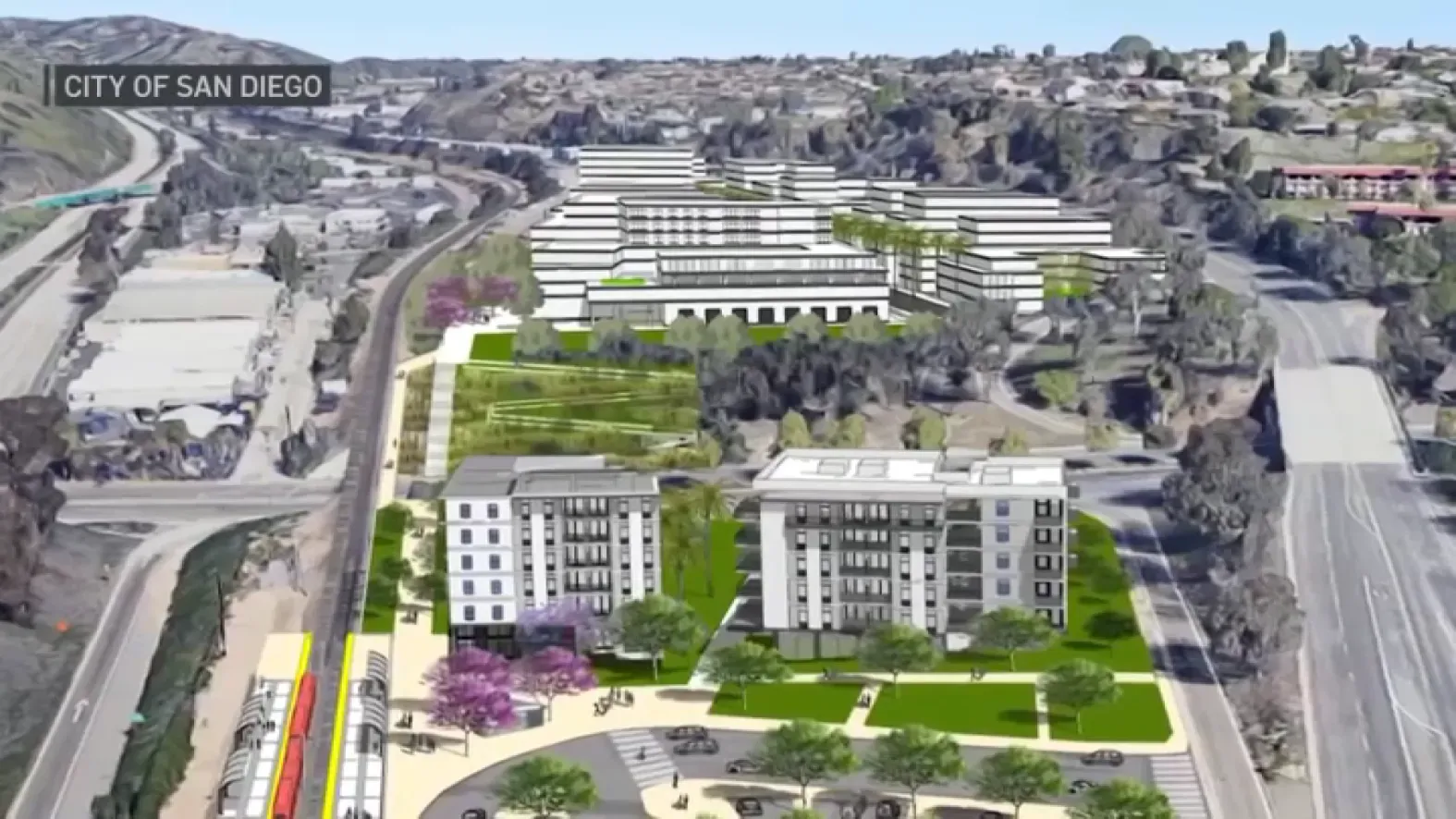
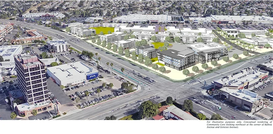
Clairemont’s first major plan update in more than three decades revises zoning, mobility networks, and open-space policies across Clairemont, including Bay Ho and Bay Park. It focuses new growth along Morena Boulevard, Balboa Avenue, Clairemont Drive, and Clairemont Mesa Boulevard. These areas are all designated for transit-oriented development. The approved plan allows for nearly 20,000 additional homes to be built in Clairemont, including the unrealized construction from the prior plan.
- Rezones corridors for mid-rise mixed-use housing and retail.
- Adds bike lanes, pedestrian safety upgrades, and bus-priority corridors.
- Certain zones will remove parking requirements if affordability, transit proximity, and mobility criteria are met.
- Encourages small-scale infill housing within existing residential areas.
Before vs. Now
Before: Clairemont’s old plan (1989) limited growth mainly to single-family lots, with patchwork commercial zoning near Morena Boulevard and Balboa Avenue.
Now: The new plan designates mixed-use concentrated “nodes” along major corridors, increases height limits near transit, and integrates climate-focused design standards citywide.
Why the City Says It’s Needed
- To align with Blueprint SD and create a transit-friendly community.
- To address housing affordability and supply shortages.
- To reduce reliance on cars through mixed-use development patterns.
- To replace an outdated plan inconsistent with modern mobility goals.
Why Some Clairemont Residents Oppose
- Fears of increased traffic and loss of parking, especially along Balboa and Genesee corridors.
- Concerns that fire and police resources will not be sufficient to meet the expected population growth.
- Concerns over building height and loss of views near canyon edges.
- Belief that new housing will strain schools, parks, and parking supply.
- Frustration that the city did not prepare a full Environmental Impact Report (EIR) for the update.
In Plain Terms
The Clairemont Community Plan opens the door to more housing and denser corridors while promising safer streets and additional parks. Supporters call it innovative modernization, with many at the meeting expressing they would have liked even more density. Critics say the plan dilutes the community’s character and poses significant risks due to increased traffic and fire hazards. Either way, Clairemont will look very different by 2050.
The College Area Community Plan Update
Public Comments: 158 opposed, 32 in favor
Outcome: Approved 7–1 by the City Council; Raul
District 9 Councilmember Sean Elo-Rivera commented, “This update is badly needed, and it’s been badly needed for a long time. I think we are going to be able to take a major step forward with the plan that’s in front of us.”
What It Does
The new College Area Community Plan is the first comprehensive rewrite in over 30 years. It allows more housing near San Diego State University and along El Cajon Boulevard and Montezuma Road. It also updates mobility, open space, and land-use maps to align with citywide housing and climate goals. The approval greenlights a 322% increase in housing units.
- Rezones major corridors for mixed-use and multifamily housing.
- Encourages infill housing within walking distance of SDSU and transit.
- Reduces parking requirements and adds new bike and pedestrian connections.
- Updates land-use designations to support Complete Communities zoning.
Before vs. Now
Before: The old College Area plan (1989) limited density, required large parking lots, and emphasized single-use zoning with separate residential and commercial areas.
Now: The new plan consolidates zoning categories, allows taller mixed-use buildings near transit, and introduces flexible density standards tied to mobility rather than strict lot size.
Why the City Says It’s Needed
- To meet state housing mandates under the Regional Housing Needs Allocation (RHNA) and Senate Bill 10 (SB 10). SB 10 allows for up to 10 residential units on a single parcel in transit-rich areas without an environmental review.
- To reduce commute traffic by placing housing near jobs and schools.
- To align with citywide plans like Blueprint SD and the Climate Action Plan.
- To create predictable zoning instead of case-by-case variances.
Why Some College Area Residents Oppose
- Concerns about increased traffic and parking shortages near San Diego State University.
- Residents feel the plan is an overreach, particularly in light of their proposed 7 Visions Plan, which would have led to a 137% increase in housing.
- Fears that infrastructure and public services cannot keep up with growth. College Area currently does not have its own fire or police station.
- Criticism that the city used an EIR addendum instead of preparing a full Environmental Impact Report.
In Plain Terms
The College Area plan increases housing near SDSU and modernizes decades-old zoning. Supporters say this is long overdue, especially considering the lack of nearby housing for SDSU residents and alumni. Critics argue that the area lacks the infrastructure to support this level of growth, and they are taking on an unfair burden compared to other communities.
For residents, it means faster approvals for new housing projects and less neighborhood-level control over what gets built.
The Community Enhancement Overlay Zone (CEOZ)
Outcome: Approved by the City Council
What It Does
The Community Enhancement Overlay Zone (CEOZ) is a citywide framework that replaces the old Community Plan Implementation Overlay Zone (CPIOZ). It moves local design standards from individual plan documents into the San Diego Municipal Code.
- Creates a uniform citywide overlay for design and connectivity standards.
- Removes prior overlays from the Clairemont and College Area plans.
- Applies consistent rules for public spaces, walkability, and streetscape design.
Before vs. Now
Before: Each community plan had its own overlay, allowing neighborhoods to write their own design and review standards, taking into consideration their unique understanding of their individual communities.
Now: The CEOZ standardizes those across the city. Enforcement shifts to the Planning Department, reducing local variation.
Why the City Says It’s Needed
- Streamlines permitting and removes duplicative overlays.
- Helps the City comply with state housing laws such as SB 10, RHNA, and Senate Bill 330 (SB 330).
- Ensures all communities follow consistent design and infrastructure standards.
- Prevents inconsistent community-level rules that could block housing.
Why Residents Call It a Loss of Control
- Local communities can no longer tailor overlay rules to their individual areas.
- Community Planning Group (CPG) recommendations have less influence on individual projects.
- Environmental review and design oversight are centralized.
- Concerns about parks and recreation deficits.
- Uniform standards may overlook unique conditions like canyons or traffic issues.
In Plain Terms
The CEOZ does not eliminate public input, but it shifts control from community-specific boards to City Hall. Planning becomes more standardized and faster, but also less locally flexible.
The Environmental Question: What’s an EIR, and Why It Matters
An Environmental Impact Report (EIR) is a study required under the California Environmental Quality Act (CEQA) that evaluates a project’s effects on traffic, air quality, and the environment.
The City used an addendum to its 2024 Blueprint SD Program EIR instead of preparing a new EIR for these plan updates. City planners say it is sufficient, while naysayers say it bypasses public review and hides unaddressed impacts.
In simple terms: City Hall says the data is already there. Residents say the impacts have changed, and the study should reflect those changes.
What Happens Next
City officials say implementation will occur gradually, based on community demand and meeting infrastructure requirements. But community debate over growth, local control, and environmental review is likely to continue.
With the recent adoption of Senate Bill 79, a statewide law that will override local zoning laws to allow significant upzoning near transit areas, the future of what our communities will look like still remains uncertain.